-
Publications
-
REFEREED JOURNAL PUBLICATIONS (Since 2015)
(*Student co-author)
- Li J., Wang X., He Z*., Zhang T., 2021. A personalized activity-based spatiotemporal risk mapping approach to COVID-19 Pandemic. Cartography and Geographic Information Science.
- Li J., Wang X., Zhang T., 2021 Sequence-based centrality measures in maritime transportation networks. IET Intelligent Transport Systems. 14(14), p. 2042-2051.
- Yu, M., Bambacus, M., Cervone, G., Clarke, K., Duffy, D., Huang, Q., Li, J., Li, W., Li, Z., Liu, Q. and Resch, B., 2020. Spatiotemporal event detection: a review. International Journal of Digital Earth, doi: 10.1080/17538947.2020.1738569.
- Wang X*., Li J., Zhang T., 2019 A Machine-Learning Model for Zonal Ship Flow Prediction Using AIS Data: A Case Study in the South Atlantic States Region. Journal of Marine Science and Engineering, 7(12), 463.
- Li J., Xu Y*., Macrander H*., Atkinson L*., Thomas T*., Lopez M., 2019. GPU-based lightweight parallel processing toolset for LiDAR data for terrain analysis. Environmental Modeling and Software. 117: 55-68.
- Zhang, T., Zeng, Z., Li, J. 2019. Reinforcement learning-driven address mapping and caching for flash-based remote sensing image processing. Journal of Systems Architecture.
- Wang, X*., Rafa, M., Moyer, J. D., Li, J., Scheer, J., Sutton, P. 2019. Estimation and Mapping of Sub-National GDP in Uganda Using NPP-VIIRS Imagery. Remote Sensing, 11(2), 163.
- Zhang, T., Li, Y., Yang, H., Cui, C., Li, J., Qiao, Q. 2018. Identifying primary public transit corridors using multi-source big transit data. International Journal of Geographical Information Science, 1-25.
- Zhang T., Li J., 2018. Automatic cloud resource provisioning and management for interactive remote geovisualization using reinforcement learning. Transactions in GIS. 22(6): 1437-1461.
- Li J., Wang X., Zhang T., Xu Y., 2018. Efficient K Best Connected Trajectory (K-BCT) query on GPGPUs: a combinatorial min-distance and progressive bounding box approach. ISPRS International Journal of Geo-Information. 7(7):239.
- Zhang T., Luo P., Li J., Cheng Z., 2018. Efficient flash-aware page-mapping cache management for on-board remote sensing image processing. Journal of Systems Architecture. 88, 1-12.
- Zhang T., Dong. S., Zeng Z., Li J., Quantifying multi-modal public transit accessibility for large metropolitan areas: a time-dependent reliability modelling approach. International Journal of Geographic Information Science. 32(8):1-28.
- Li J., Finn M., Blanco-Castano M*. 2017. A lightweight CUDA-based parallel map reprojection method for raster datasets of continental to global Extent. ISPRS International Journal of Geo-Information. 6(4), 92.
- Huang Q., Li J., Li Z. 2017. A hybrid cloud platform framework based on multi-sourced computing and model resources for Geosciences. International Journal of Digital Earth. 4, 1-21.
- Li J., Zhang T., Liu Q*., Yu 2017. Predicting visualization intensity for interactive spatiotemporal visual analytics: A data-driven view-dependent approach. International Journal of Geographic Information Science. 31(1), 168-189.
- Li J., Zhang T., Wong D., Mooney M*. 2016. A view-dependent spatiotemporal saliency-driven approach for remote geovisualization. Computers, Environment and Urban Systems. 59, 64-77.
- Zhang T., Li J., Liu Q*., Huang Q. Cloud-enabled remote visualization for time-varying climate data analytics. Environmental Modeling and Software. 75:513-518.
- Zhang T., Zeng Z., Tao J., Li J. Examining the amenability of urban street networks for locating facilities. Physica A: Statistical Mechanics and its Applications. 457, 469-479.
- Zhang T., Yan W., Li J. Chen J. 2016. Multi-class labeling of very high-resolution remote sensing imagery by enforcing non-local shared constraints in multi-level conditional random field models. IEEE Journal of Selected Topics in Applied Earth Observations and Remote Sensing. PP (99):1-14.
- Zhang T., Li J. Online task scheduling for LiDAR data preprocessing on hybrid GPU/CPU devices: A reinforcement learning approach. IEEE Journal of Selected Topics in Applied Earth Observations and Remote Sensing. 8(1): 386-397.
REFEREED BOOK CHAPTERS (Since 2015)
- Wang X*., Li J., Zhang T., 2020. Building a GPU-enabled analytical workflow for maritime pattern discovery using Automatic Identification System data. In: Tang W., Wang S., eds. High Performance Computing for Geospatial Applications. Springer.
- Huang Q., Li J., Zhang T., 2020. Domain Application of High Performance Computing in Earth Science -- An Example of Dust Storm Modeling and Visualization. In: Tang W., Wang S., eds. High Performance Computing for Geospatial Applications. Springer.
- Li J., Kai L., Huang Q. 2016. Utilizing cloud computing to support scalable atmospheric modeling: A case study of cloud-enabled ModelE. In: Vance T., Merati N., Yang C., Yuan M., eds. Cloud Computing for the Ocean and Atmospheric Sciences. Elsevier, pp. 347-363.
SELECTED PROFESSIONAL PRESENTATIONS (Since 2015)
- “A grid-based hierarchical decomposition strategy for memory-efficient LiDAR processing with GPUs”. AGU Fall Meeting 2019, San Francisco, December 9 -13, 2019
- “A visual based spatiotemporal sequence mining approach to maritime transportation”, 115th AAG Annual Meeting, Washington DC, April 3- 7, 2019.
- “Building a CUDA-Based Parallel Processing Library for 3DEP”, 114th AAG Annual Meeting, New Orleans, April 9 - April 13, 2018.
- “Intensive Spatiotemporal Visual Analytics in Collaborative Computing Environment”, 1st International Symposium on Spatiotemporal Computing, Fairfax, Virginia, July 13 – 15, 2015.
FUNDED PROJECTS (Since 2015)
- Towards developing a GPU cloud based visual analytics framework for large scale Earth science data. Microsoft. 2018, 2019.
- Earth on AWS Cloud Credits for Research Application, Amazon Web Service (AWS). 2017.
- AB105 Security-enabled desktop client (EOC Desktop Client) for Open Geospatial Consortium (OGC) Testbed 13. Open Geospatial Consortium (OGC). 2017.
- Develop a GPU-based remote data processing prototype system to support the 3D Elevation Program (3DEP). US Geological Survey (USGS), Center of Excellence in GIS (CEGIS). 2016.
-
Research projects
-
GEOAI FOR DATA-DRIVEN URBAN APPLICATIONS
- Urban Environment: Build AI methods to predict fine level air quality in cities.
- Transportation: Apply AI to analyze movement patterns and predict resource usage, such as public transit, for better planning.
- Health: Use travel logs and AI to evaluate individuals' air pollutant exposure and possible health outcomes.
(Left: Major corridors identified from public transit systems using smart card data; Right: Community transmission of COVID-19 on 04/12/2020 in Denver Metro, two weeks after Stay@Home order issued )
SPATIOTEMPROAL VISUALIZATION
- Develop novel geovisualization algorithms to represent multidimensional geospatial data that capture dynamic environmental processes (e.g., wind, dust movement).
- Discover the spatiotemporal principles in governing the efficiency and the effectiveness of geovisualization.
- Design computational solutions that leverage the state-of-the-art computing solutions(e.g., Cloud computing) to improve the performance of geovisulaization.
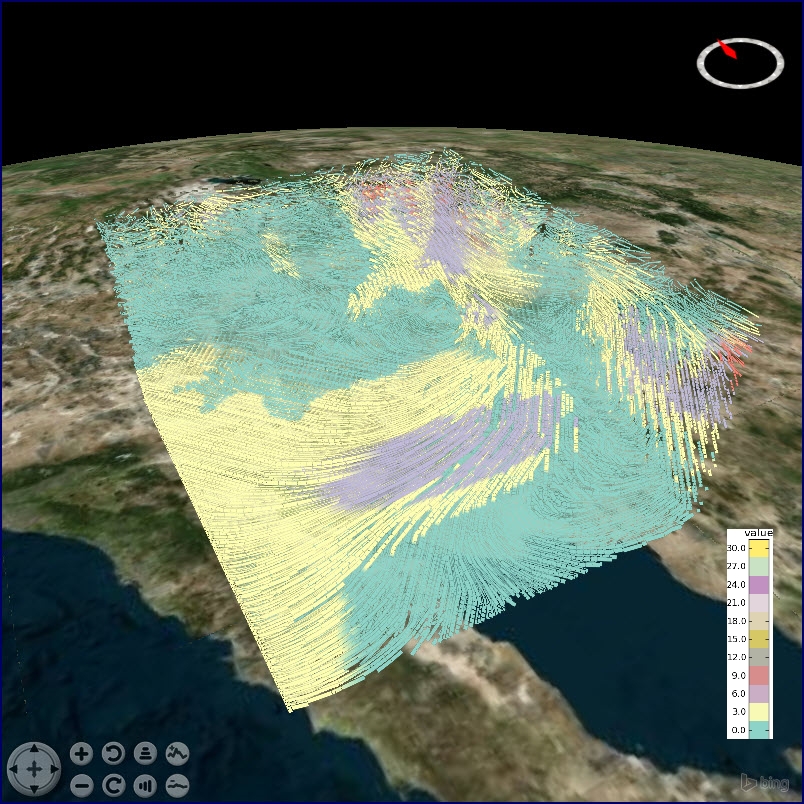
(Left: Isovolume of wind speed from model simulations; Right: Backbone network extracted from ship trajectories)
Online Link: http://geovizcloud.github.io/GeoVizCloud/
HIGH PERFORMANCE GEOCOMPUTATION
- Leverage cloud computing and GPU computing techniques to improve computing-intensive problems (e.g., LiDAR processing, interactive visualization)
- Design methods to improve cloud-based task scheduling and resource allocation to support geospatial computing
(Left: An example of Kernel Density Estimation-KDE; Right: Time costs of running parallel processing algorithms)
Online link: https://lidarlib.github.io/gpulidarproj/